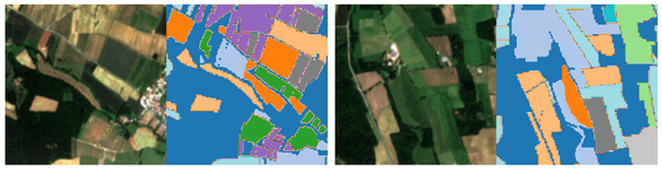
Figure 1. The picture shows two examples of segmentation of a Sentinel-2 patch; for each patch, we see on the left the RGB composite satellite image, and on the right the corresponding segmentation of crop fields with the different colors indicating different types of crops. Courtesy of V. Sainte Fare Garnot, L. Landrieu, and N. Chehata, “Multi-modal temporal attention models for crop mapping from satellite time series,” ISPRS Journal of Photogrammetry and Remote Sensing, vol. 187, pp. 294–305, May 2022, doi: 10.1016/j.isprsjprs.2022.03.012.
Crop Classification using HPC and Deep Learning
by Andrea Miola and Sebastiano Fabio Schifano
Agriculture is instrumental in several facets of human progress, acting as a catalyst for overall economic advancements of Countries, providing livelihoods to populations, supplying raw materials, and contributing to global trading. For these reasons, it is important to accurately map the types of crops present in different regions of the Earth. This process is named crop classification (see Fig. 1) and consists of assigning a crop class to different regions on a geospatial grid. It is a fundamental branch of Earth Observation (EO) studies, and relevant for developing and implementing programs to reduce and alleviate the environmental impacts of intensive agriculture, promoting specific areas to be extensively cultivated as grassland, the use of biodiversity, and specific crop mixes in the rotation of fields to develop sustainable use of water resources.
In the last decades, the advent of remote sensing technologies with either satellites or unmanned aerial vehicles (UAV) has revolutionized this process, and more in general the EO science, providing valuable and accurate insights. In particular, the large amount of high-resolution data coming for example from the LandSat constellation, the Copernicus Sentinel program, and more recently also from the Planet constellation, enabled the development of extensive studies on yield predictions, soil classifications, and crop mappings.
The recent development of GPU-accelerated computing has made possible the exploitation of Deep Learning (DL) methods for several applications, including crop classification and analyzing and processing Big Data using innovative approaches to find correlations among them. DL algorithms can be used to analyze high-resolution multitemporal satellites with more information for crop classification compared to the simple analysis of a single image since seasonal differences in the growth processes of different crops can provide useful discriminating features to make identification based on phenology and spectral signatures. This approach requires high-performance computing (HPC) systems since DL algorithms are known to be very computing-heavy, and recent multi-GPU HPC systems can boost by one or two orders of magnitude the processing power of classical computing systems based only on CPUs.
Within the MESEO project, UNIFE would like to bring long-term expertise in designing and developing of High-Performance Computing applications to deploy a neural network model to make reliable and fast crop classification from multitemporal multispectral satellite images. In particular, the main contributions UNIFE aims to implement are fourfold:
the design of a DL model performing crop segmentation on multispectral and multitemporal satellite images;
the creation of multitemporal multispectral datasets to train the model;
the implementation and optimization of the model to run on multi-GPU HPC systems, supporting distributed training and inference;
the assessment of the model performance in terms of prediction accuracy, computing, and scalability across different multi-GPU systems, comparing the results achieved with state-of-the-art related works.