

Crop Classification
The Challenge
Accurate monitoring and tracking of crop locations, development, and health is essential for sustainable agriculture, providing the baseline data needed for environmental monitoring, smart resource management, and climate resilience.
Traditional methods rely on single-date snapshots, capturing only static views of fields and missing the seasonal dynamics that distinguish one crop from another.
Producing consistent, large-scale crop maps therefore requires processing huge volumes of multi-temporal satellite imagery captured at different times across several months of the growth cycles, a computationally demanding task whose processing time and energy footprint grow rapidly with the area covered.
MESEO’s Approach
Within the MESEO project, UNIFE bridges the gap between massive satellite data and actionable agricultural insights. By combining Artificial Intelligence with High-Performance Computing, we automatically generate accurate, large-scale crop classification maps.
Unlike traditional methods that rely on single-date snapshots, our approach analyses multi-temporal, multi-spectral satellite imagery gathered throughout the growing season. This captures each field’s seasonal growth dynamics, allowing our neural network to identify unique phenological “signatures” and produce consistent, reliable classification maps.
At the core of this process is AgrUNet (Figure 1), a convolutional neural network based on the U-Net architecture, a standard for image segmentation.
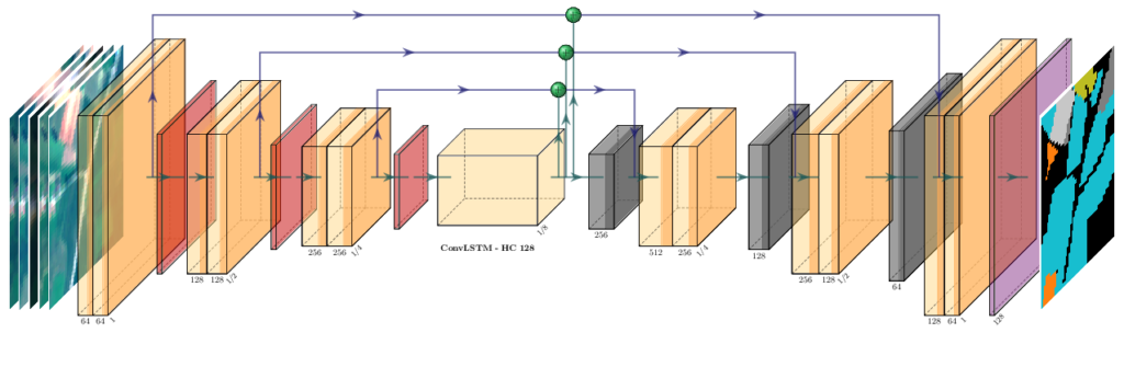
As shown in the diagram above, the model follows the classic U-Net encoder-decoder structure: the downward encoder captures spatial features, while the upward decoder reconstructs the segmentation maps. At each layer, 3D convolutions are applied, while at the bottleneck a Long Short-Term Memory (LSTM) convolution operation is computed. The first two blocks model the spatial structures, while the latter models the temporal evolution.
Technologies Involved
AgrUNet is a crop classification model designed for efficiency and scalability. It is written in Python using the PyTorch Lightning framework and supports distributed training and inference across multi-GPU platforms.
Complex convolution operators make the computation demanding, requiring significant processing power. To ensure fast, energy-efficient performance, we leverage GPU acceleration, utilising automatic mixed precision, multi-device scaling, and deep supervision. This approach also prioritises “Green Computing”, shifting inference from CPU to GPU so that the same map is produced at a fraction of the energy cost.
Input data and processing chain
Our model operates on Copernicus Sentinel 2 data products, but can be easily extended to support and run on products provided by other satellites. For each area of interest, a time series of approximately 20 acquisitions is assembled across the January-July period. The model processes 10 spectral bands (B2, B3, B4, B5, B6, B7, B8, B8A, B11, B12), resampled to a common ground sampling distance of 10 m and, during inference, each time series is tiled into patches of 128×128 pixels for GPU processing.
AgrUNet is trained separately on each of two open-source multi-class datasets: OrthoPASTIS, a refined version of the PASTIS dataset, with 18 crop classes, and Munich, with 17, yielding one model per dataset. The output is a color-coded crop classification map delivered as both a GeoTIFF raster and Shapefile vector file at 10 m resolution.
Other training datasets can be easily used to specialize the model over different areas with different phenological crop signatures.
Deployment
AgrUNet is packaged as a Docker-based microservice, ensuring portability and automatic execution within the MESEO platform. When a user selects an area of interest, the GMV Prodigi® orchestrator automatically triggers the process to generate the crop maps, turning raw remote-sensing data into a practical decision-support tool for agriculture. The crop classification use case demonstrates the capability of MESEO to process data from catalogues, since it requires long time series spanning several months to produce accurate results.
Demonstrated Results
Benchmark validation
Validated on their respective datasets, the two models achieve Dice segmentation scores of 0.86 (OrthoPASTIS) and 0.93 (Munich). AgrUNet also scales almost linearly on multi-GPU architectures, cutting the time needed to process large areas compared to conventional approaches. Training and benchmarking are carried out on the GPU cluster installed at the University of Ferrara and operated in collaboration with INFN, which hosts 4× NVIDIA V100 GPUs connected by high-speed NVLink interconnects.
MESEO demonstration
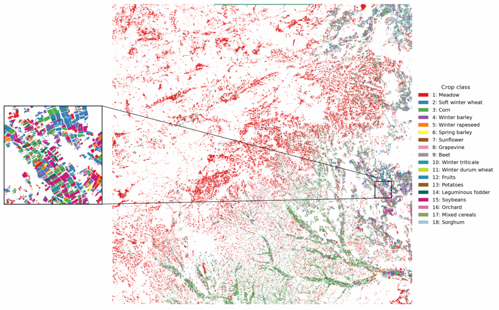
AgrUNet has been run end-to-end inside the MESEO platform over a Sentinel-2 tile located South-West of Vienna (Austria), covering approximately 110×110 km (~12,100 km²) for the 2025 growing season. The map was produced with the OrthoPASTIS model, demonstrating the ability of the model to generalise to a country absent from its training set. Across the 18 crop classes, the map reaches an overall accuracy of 87%, with the classes covering most of the area (e.g., soft winter wheat, corn, winter barley and winter rapeseed) achieving the highest scores.
The complete area of interest is processed in about 30 minutes on a single NVIDIA V100, from the ingestion of the Sentinel-2 time series to the delivery of the final product, corresponding to roughly 400 km² of mapped land per minute of GPU time.
Figure 2 shows the resulting crop classification map, with one colour per class. Areas left in white are classified as background, i.e., non-agricultural land. The zoomed-in inset shows individual parcels and their boundaries, confirming that the model works at field scale rather than producing a coarse regional average.
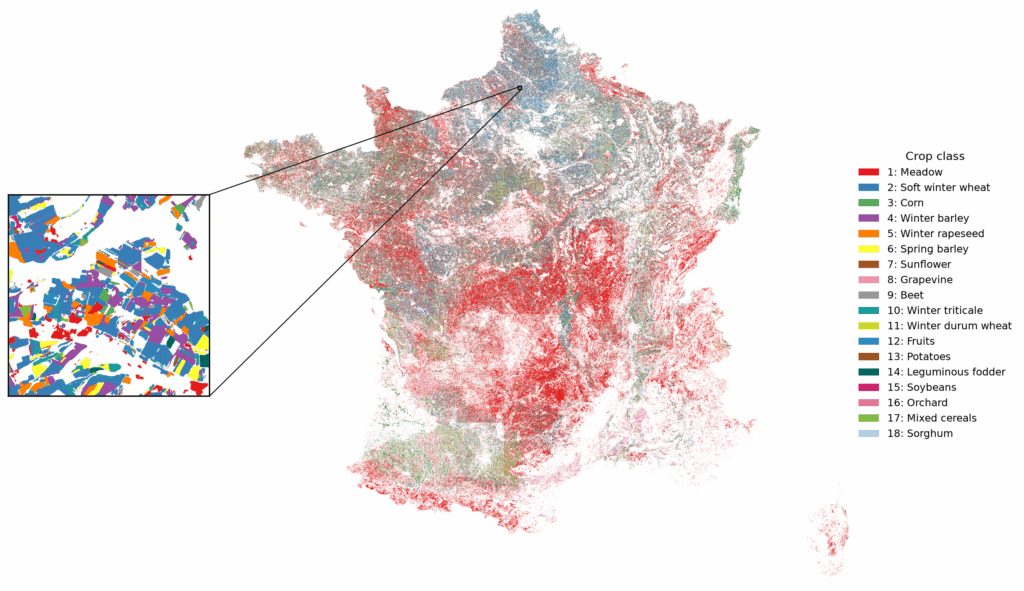
The same workflow scales to entire countries. Figure 3 shows a crop map of France for 2023, obtained with the same OrthoPASTIS model by processing the 86 Sentinel-2 tiles that cover the country, roughly 550,000 km² in total. The number of usable observations varies from tile to tile, ranging from 12 to 61 images over the January-July window. After the inference, the individual tiles were harmonised and mosaicked into a single country-scale product. The full mosaic required approximately 11 hours of processing on 4× NVIDIA V100.
The effect of the time-series length variability is visible in a few places, where the dominant class changes abruptly along a tile edge. Tiles with fewer usable acquisitions capture less of the crop growth cycle, leaving the model with less phenological information to separate similar crops.
Energy efficiency
By shifting inference from CPU to GPU with mixed precision, we reduce energy consumption per image from 584 to 6 joules, a reduction of approximately 99% (see Table 1).
| Watt | J / img | ||
|---|---|---|---|
| Inference | CPU - FP32 | 132 | 584 |
| GPU - FP32 | 235 | 18 | |
| GPU - AMP | 185 | 6 | |
| Training | CPU - FP32 | 132 | 1891 |
| GPU - FP32 | 258 | 86 | |
| GPU - AMP | 185 | 20 |
This demonstrates that for sustainable AI, efficiency is best achieved through high throughput rather than low power draw alone. For example, classifying one million samples (each a 19-date × 10-band × 128 × 128 pixel cube) on a CPU generates roughly 72 kg of CO₂, while our GPU-optimised approach emits only about 740 g (based on an IEA grid-intensity estimate of 445 g CO₂/kWh).
Future Exploitation
AI for Agricultural Monitoring
MESEO has also demonstrated the potential of Artificial Intelligence for analysing agricultural areas using Earth Observation data.
Advanced processing methods applied to multi-temporal Sentinel-2 imagery can support crop classification and the generation of agricultural information products.
Future research may expand these capabilities to additional geographic regions, crop types and datasets, improving the robustness and applicability of automated crop mapping.
The results offer opportunities for continued scientific development and potential applications in agricultural monitoring, land management and environmental assessment.